For Sale - £2,565,000 - 152.54 acres, Middle Farm, Ashwell, Oakham, Rutland, LE15 7LJ
![]()
Fisher German
The Estates Office, Norman Court, , Ashby de La Zouch, Leicestershire LE65 2UZ
Tel:01530 412821
Fax: 01530 413896
E-mail: ashbyagency@fishergerman.co.uk
|
|
|
|
|
|
|
|
|
|
|
|
|
|
|
|
|
|
|
|
|
|
|
|
|
|
- Early 18th century listed farmhouse
- Traditional and Modern Buildings
- About 152.54 acres in all
- Available as a whole or in up to 5 lots
- For sale by informal tender
- Deadline for offers 12 noon Friday 4th April 2025
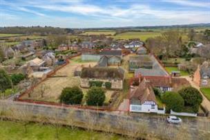
An exceptionally well located mixed farm with Grade II listed dwelling in Ashwell village.
Description
Available as a whole or in up to 5 lots.
For sale by informal tender.
Deadline for offers 12 noon Friday 4th April 2025.
Property Overview
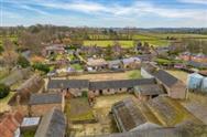
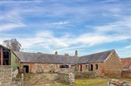
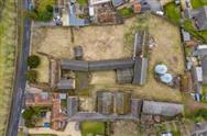
An exciting opportunity to purchase a mixed arable and grassland farm with early 18th century listed farmhouse, extensive range of traditional buildings and extending to about 152.54 acres in all.
• Grade II listed two-storey 2,411 sq. ft., four-bedroom farmhouse.
• Significant range of well-presented traditional buildings extending to about 4,519 sq. ft. with scope for alternative uses (STP).
• Modern steel portal general-purpose farm buildings extending to about 5,000 sq. ft. and grain stores.
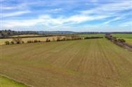
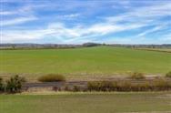
• About 151.01 acres (61.11 ha) of productive arable land and permanent pasture.
• Vacant Possession available upon completion (subject to tenancy in part).
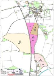
Available as a whole or alternatively in up to five lots:
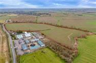
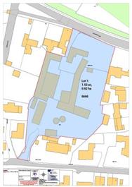
• Lot 1 – Listed farmhouse, traditional and modern farm buildings and grounds extending in all to about 1.53 acres (0.62 ha).
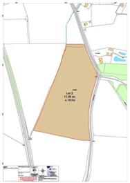
• Lot 2 – About 15.28 acres (6.18 ha) of permanent grassland.
• Lot 3 - About 33.02 acres (13.36 ha) of productive arable land and amenity land.
• Lot 4 – About 80.50 acres (32.58 ha) of productive arable land.
• Lot 5 – About 22.21 acres (8.99 ha) of productive arable land.
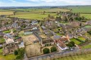
Situation
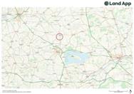
Middle Farmhouse is situated in the centre of Ashwell village, a highly desirable village in Rutland. Transport links are excellent with the market town of Oakham just 3 miles to the south, providing an array of shops, leisure facilities, public houses and independent eateries. There are numerous local independent and state schools including Oakham and Uppingham School. Stamford (12.6 miles) lies to the south east and provides a wide range of larger department stores, public houses and eateries. The market town of Uppingham lies 9.6 miles to the south.
Rutland water lies 6.8 miles to the south east providing a range of leisure and outdoor pursuit opportunities including fishing, cycling, sailing and windsurfing along with a renowned nature reserve.
The A1 lies just 6 miles to the east providing access to the wider national road network.
Oakham railway station (3.6 miles) provides direct services to Birmingham, Leicester and Stansted Airport. East Midlands Airport is about 32 miles away.
The farm provides significant amenity and lifestyle appeal and will be of interest to a wide range of agricultural, equestrian, lifestyle, developer, and investment purchasers.
Description
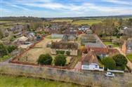
Middle Farm, Ashwell provides a rare opportunity to purchase a mixed farm of about 152.54 acres which will appeal to a broad range of purchasers, with development potential (STP). The farmhouse and buildings are located in the centre of Ashwell village in a very attractive part of the County of Rutland in the East Midlands.
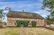
The attractive thatched listed farmhouse provides accommodation over two floors and provides a rare opportunity to refurbish and modernise a historic village centre residence. The traditional outbuildings provide significant scope for redevelopment and/ or change of use to residential, commercial, equestrian or similar use (subject to the necessary consents).
The property is available as a whole or alternatively in up to five lots as follows:
Lot 1 – Listed farmhouse, traditional and modern farm buildings and grounds extending in all to about 1.53 acres (0.62 ha)
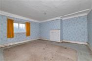
The farmhouse is an impressive Grade II listed detached farmhouse built in the early 18th century. It is situated in the centre of Ashwell village with access from both Cottesmore Road to the north and from Brook Dene to the south.
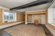
The two-storey farmhouse is constructed primarily of stone with a thatched roof on the main structure and a concrete tiled roof to the rear and extends to about 2,411 sq. ft. There is a more modern 20th century porch with tile roof to the rear of the property.
The accommodation is spread over two floors and includes an entrance hall, dining room, sitting room, rear hall with stairs, utility room, storeroom/ pantry, and kitchen on the ground floor. The first floor comprises a landing, four double bedrooms, a store, and a bathroom.
The farmhouse overlooks gardens to the north and eastern elevations, laid mainly to lawn with some flower beds.
Please note: the farmhouse is presented in poor condition and requires a complete refurbishment throughout, and a scheme of modernisation, (subject to all necessary consents).
There is currently no central heating system in place. The property is single glazed throughout. Ample off-road parking is provided for numerous vehicles.
Lot 1 falls within the within the Ashwell Conservation Area and is subject to an article 4 (1) Direction.
The property was listed in 1984 under List Entry Number: 1073272
EPC: N/A
Council Tax Band: G
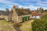
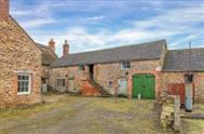
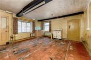
Traditional Farm Buildings
The traditional buildings in Lot 1 may present potential for conversion to a wide variety of uses including home office space, independent residential and/ or ancillary residential use, commercial uses, and equestrian use (subject to the necessary consents).
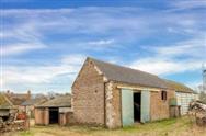
The traditional buildings are arranged in a courtyard format to the south of the farmhouse and extend to about 4,519 sq. ft. including stables, former cattle stores and general stores. The buildings are generally of stone and/or brick construction under concrete tile roof. The stable yard is of brick and stone construction under a slate roof. There are single and two storey sections, with the former threshing barn comprising a very impressive double height open traditional stone barn.
The traditional buildings are in need of some maintenance and repair works in the short term but provide a highly attractive redevelopment opportunity for prospective purchasers (subject to necessary consents).
Modern Farm Buildings
The modern farm buildings comprise two steel portal frame general purpose barns, a concrete block and steel portal frame Dutch barn, grain bins, and a further general-purpose barn. There is a redundant Nissen hut and two freestanding grain silos.
The modern farm buildings extend to about 5,000 sq. ft. and may present further redevelopment opportunities subject to the necessary consents.
Please refer to floor plan of farm buildings for measured survey (excluding grain bins and Dutch barn).
Please note: We believe a number of roof coverings may include asbestos containing fibre cement roof coverings.
General Matters
A number of building surveys have been commissioned (January 2025) to include the farmhouse and traditional buildings. These surveys will be available to seriously interested parties only.
A right of pedestrian access is provided along part of the driveway from Cottesmore Road for the benefit of a neighbouring property. This right is provided by way of an annual licence which expires September 2025.
We understand a further neighbouring property has the benefit of a temporary right of way and for car parking off Brook Dene to the south of Lot 1.
Please note: Viewings are strictly by appointment only and interested parties are not permitted to access Lot 1 unaccompanied.
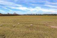
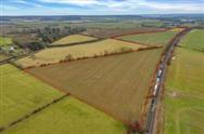
Lot 2 – About 15.28 acres (6.18 ha) of permanent grassland
Lot 2 comprises a ring-fenced block of permanent grassland with access directly from Oakham Road along the eastern boundary. There is evidence of historic ridge and furrow to the north of the land parcel.
The land is classified as being Grade 3 and according to Soilscape (England) the soils may be described as slowly permeable seasonally wet slightly acid but base-rich loamy and clayey soils. Such soils are generally suited to grass production for dairying or beef; some cereal production often for feed.
The boundaries generally comprise mature hedgerows and post and wire fencing in part.
An 11kV electricity overhead line crosses the land.
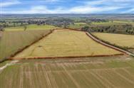
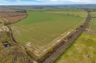
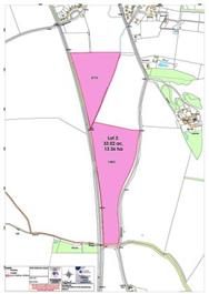
Lot 3 – About 33.02 acres (13.36 ha) of productive arable land and amenity land
Lot 3 comprises a ring-fenced block of arable land with a small area of amenity scrub land to the south, in two distinct field parcels.
Access is taken directly from Oakham Road along the eastern boundary.
The arable land is classified as being Grade 3 and according to Soilscape (England) the soils may be described as slowly permeable seasonally wet slightly acid but base-rich loamy and clayey soils. Such soils are generally suited to grass production for dairying or beef and some cereal production often for feed. The boundaries generally comprise mature hedgerows.
The land is currently cropped with a first wheat.
An 11kV electricity overhead line crosses the land.
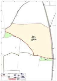
Lot 4 – About 80.50 acres (32.58 ha) of productive arable land
Lot 4 comprises a ring-fenced block of arable land with access taken from Langham Road to the western boundary. We understand a right of way exists from Oakham Road over the railway line to the southern boundary, for agricultural purposes.
The arable land is classified principally as being Grade 3 and according to Soilscape (England) the soils may be described as slowly permeable seasonally wet slightly acid but base-rich loamy and clayey soils. Such soils are generally suited to grass production for dairying or beef and some cereal production often for feed. The boundaries generally comprise mature hedgerows.
The land is currently cropped with a first wheat.
A bridleway way runs along the southern boundary from Langham Road heading east to Oakham Road.
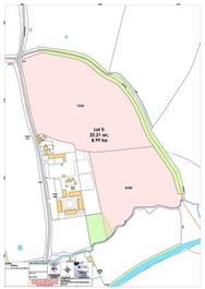
Lot 5 – About 22.21 acres (8.99 ha) of productive arable land
Lot 5 comprises a ring-fenced block of arable land with access taken from Oakham Road along an unmade track to the northern boundary.
The arable land is classified principally as being Grade 3 and according to Soilscape (England) the soils may be described as slowly permeable seasonally wet slightly acid but base-rich loamy and clayey soils. Such soils are generally suited to grass production for dairying or beef and some cereal production often for feed. The boundaries generally comprise mature hedgerows.
The land is currently cropped with a first wheat.
A bridleway way crosses a small section of the land along the eastern boundary. Part of the land to the south falls with flood zone 2 and 3. We understand there is a mains water supply connection.
Fixtures and Fittings
All other fixtures and fittings, garden ornaments, stone troughs and statuary are excluded. Some may be available by separate negotiation. The inclusion or exclusion of any agricultural fixtures and fittings is to be discussed.
Services
Lot 1 - The farmhouse – Mains drainage, mains electricity and mains water connections. Mains electricity and water connected to some farm buildings.
Lots 2, 3 and 4 –We are not aware of any mains or private services connected.
Lot 5 – We understand there is a mains water supply.
The estimated fastest download speed currently achievable for the property postcode area is around 1000 Mbps (data taken from checker.ofcom.org.uk on 18/02/2025). Actual service availability at the property or speeds received may be different.
We understand that the property is likely to have current mobile coverage outdoors (data taken from checker.ofcom.org.uk on 18/02/2025). Please note that actual services available may be different depending on the particular circumstances, precise location and network outages.
Prospective Purchasers must satisfy themselves as to the availability of services and any future connections. If the land is sold in lots, then cross-rights and reservations will need to be reserved where required, for services. Services may need to be split, and sub-meters installed. None of the services, appliances or electrical systems have been tested by the selling agents.
Tenure and Possession
The freehold of the property is for sale with vacant possession on completion (subject to cropping licences across the arable farmland to harvest 2025 and grazing licence across the grassland).
Method of Sale
The property is offered for sale by informal tender and is available as a whole or in up to five lots.
Tender documents and tender conditions are available upon request from the selling agent and tenders must be submitted using the prescribed form.
All offers must be received by 12 noon Friday 4th April 2025.
Please note: the Vendors reserve the right to conclude the sale by any other means at their discretion and the Vendors are not obliged to accept the highest or indeed any Tender submitted
Rights of Way, Wayleaves and Easements
A number of public rights of way cross the property and are shown on the sale plan.
The property is sold subject to all rights of way, wayleaves, and easements whether or not they are defined in this brochure.
If the farm is sold in lots, then cross-rights and reservations will need to be reserved where required, for example for access, services and maintenance.
Plans and Boundaries
The plans within these particulars are based on Ordnance Survey data and provided for reference only. They are believed to be correct, but accuracy is not guaranteed. The purchaser shall be deemed to have full knowledge of all boundaries and the extent of ownership. Neither the vendor nor the vendor's agents will be responsible for defining the boundaries or the ownership thereof.
VAT
Any guide price quoted or discussed is exclusive of VAT. In the event that a sale of the property or any part thereof or any right to it becomes a chargeable supply for the purposes of VAT, such tax will be payable in addition to the sale price.
Minerals, Sporting and Timber Rights
The sporting, mineral and timber rights will be transferred with the freehold title where owned.
Nitrate Vulnerable Zone (NVZ)
The Property lies within a Surface Water NVZ Area and is subject to the usual restrictions.
Basic Payment Scheme and Environmental Schemes
The land has historically been registered for payments under the Basic Payment Scheme and all delinked payments and entitlements relevant to the land will be retained by the vendors and will not be available to the Purchaser on completion of the sale. There are not believed to be any environmental schemes in place.
Ingoing Crop Valuation/Holdover
No ingoing valuation will be required. The arable land is subject to a cropping licence.
Overage
Lot 1 is offered for sale with an overage provision to cover the traditional and modern farm buildings, land and yard area which will specify that 20% of any increase in value due to development (as defined in Section 55 of the Town and Country Planning Act 1990) will be payable to the Vendors or their successors in title should such development occur within 20 years from the date of completion. The uplift will be payable upon implementation or on a future sale with the benefit of a planning consent but will exclude any development for agricultural and/or equestrian use. The farmhouse is excluded from any proposed overage provision.
Successive grants of permission within the terms set out above would trigger overage. Reasonable costs incurred in obtaining planning permissions can be deducted from the overage calculations.
Lots 2, 3 and 4 are offered for sale with an overage provision which will specify that 20% of any increase in value due to development (as defined in Section 55 of the Town and Country Planning Act 1990) for renewable energy purposes only will be payable to the Vendors or their successors in title should such development occur within 20 years from the date of completion. The uplift will be payable upon implementation or on a future sale with the benefit of a planning consent.
Successive grants of permission within the terms set out above would trigger overage. Reasonable costs incurred in obtaining planning permissions can be deducted from the overage calculations.
Lot 5 is offered for sale with an overage provision which will specify that 20% of any increase in value due to development (as defined in Section 55 of the Town and Country Planning Act 1990) will be payable to the Vendors or their successors in title should such development occur within 20 years from the date of completion. The uplift will be payable upon implementation or on a future sale with the benefit of a planning consent.
Successive grants of permission within the terms set out above would trigger overage. Reasonable costs incurred in obtaining planning permissions can be deducted from the overage calculations.
Local Authority
Rutland County Council.
Viewings
Strictly by appointment and on arranged viewing days through selling agents, Fisher German LLP.
Please note the property is a working farm and viewers must take precautions with livestock and potential farm machinery on the property.
Directions
Postcode – LE15 7LJ
what3words
Lot 1 ///mows.mammoths.limitless
Lot 2 ///huddling.scrambles.observes
Lot 3 ///allies.treetop.encrusted
Lot 4 ///speedily.town.hoops
Lot 5 ///mock.tiptoes.masts
Health and Safety
For you own personal safety we ask you to take great care and be as vigilant as possible when undertaking an inspection of the property.
Note: All areas, floor areas and dimensions stated are approximate and should not be relied upon. Potential purchasers are welcome to instruct an independent survey to verify these.
Square Footage: 2411 sq ft
Acreage: 152.54 Acres
Disclaimer
Property Ref.64298_NCT250009. The information about this property is an advertisement displayed on our website by the agent referred to above. This advertisement does not comprise property particulars. AMC does not warrant its accuracy or completeness or the accuracy or completeness of any linked or associated information. Please see website terms of use